
Grand Parade (South Side)
The southern side of Grand Parade will be much more difficult to model than the northern. We have some slight assistance from Charpentier and from Commander Smythe (who drew some of the roof structures) but none of the buildings have survived into the 21st century. Much of the research will be based on the few images that are available. Principle amongst these are one from the 1860s which was used to guide the model of the northern side and one from around 1870 which we haven't used before. The 8th (King's) Regiment Memorial photo is also useful but rather oblique.
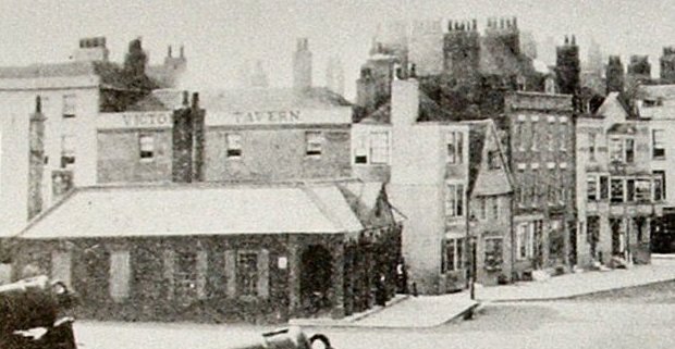
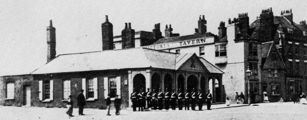
As we can see from the above, the south side of Grand Parade consists of the Guard House and four further structures. Adjacent to the Guard House but separated from it by Battery Row, is a rectangular building which is known to be the Sun Tavern. Next to this is a very old building with an overhanging gable end facing Grand Parade and beyond that a more modern structure that would not look out of place on High Street. At the far end of this block, on the corner with High Street, is the York and Pier Hotel.
This section of the model is the first we have encountered in which the house numbers in 2009 bear no relation to those that would have existed in 1860. It might have been hoped that the Trade Directories could offer some help when it came to resolving this matter and although they do list a few of the buildings we simply do not know for certain which building is which. If we assume the numbering system in Grand Parade follows the pattern in High Street, i.e. up one side and down the other, then the Sun Tavern should be No.6. but a complication arises from a map used by the Gas Company and dated 1871 (see below) in which the Sun Tavern is said to occupy the first two buildings on this block, rather than just the one on the corner. We therefore do not know if the gable ended house has a separate number at all.
The more modern building in the centre is described on the same map as being two residences whilst we also know that the York and Pier Hotel was actually listed as being in Grand Parade rather than High Street. For the sake of convenience we shall assume that the gable ended house is No. 7, the modern building consists of Nos. 8 and 9 whilst the Hotel is No. 10. This supposition is partially backed up by the Harrod's Directory which lists properties numbered 7 and 9 Grand Parade as private residences which would suggest that the corner building was No. 10 and that the gabled ended building was No. 7 and not part of the Sun.
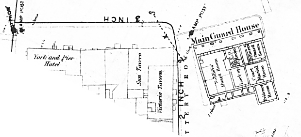
The most interesting building is the Guard House and to aid our layout we have the unusual assistance of the City Council who have laid out a plan of the walls in brick lines in their original positions on Grand Parade. This follows the plan as shown on the 1871 Gas Company map. There is a plaque at the site of the Guard House which reads as follows - "The main Guard House of Portsmouth Garrison was built during the reign of George I 1714-27. From here sentries were posted to their various duties. The centre of military activity within Portsmouth, this area was the setting for important ceremonial occasions. The building was demolished in 1883 at the time of the demolition of the town's fortifications. The works which define the stucture of the Guard House, were undertaken in 1985-6 by Portsmouth City Council on behalf of Hampshire County Council."
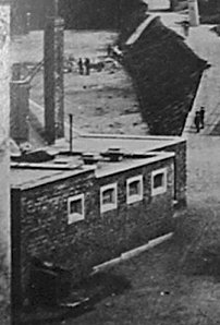
Some doubt about the completeness of the City Council ground plan emerges from a photograph (see detail right) which was probably taken from the roof of the Square Tower and which shows the back of the Guard House with a slightly different layout from that in the map. A row of cells appears to have been added to the structure. There is no definitive date for this photo but it must be before 1863 or after 1878 otherwise we might expect to see the 8th (King's) Regiment Memorial at the foot of the fortifications in the background. This alteration to the building would seem to have occurred after the publication of the 1871 map.
According to the map the Guardhouse has a frontage measuring approximately 59 feet with a maximum depth of 54 feet. The height to the under side of the roof can only be estimated using the height of the soldiers in the 1870 photo above as a guide - this equates to approximately 12 feet. The photos we have of the Guard House make it rather simple to model. The only real problem arises in determining the widths of the arches to the veranda. They are plainly not all of a similar span, the centre arch being the widest with the two either side of it the narrowest; the two arches at each end are of an intermediate width. As all the arches facing Grand Parade are of the same height then either they must be formed from ellipses, or, their sides are not tangential to the columns. Both the map and the brick layout in Grand Parade purport to define the widths but both are erratic. As there is no way an accurate depiction can be obtained from the evidence, aesthetic considerations will govern the final decision.
The extent of the Sun Tavern is difficult to determine as the map above states that it has a frontage that extends the full width of the first two buildings we can see on the block, the three storey rectangular building on the corner and the gabled building next door. It is of course possible that the Sun occupied both premises in 1860, but they are so different in architectural style that one might have expected the owners to have harmonised them in some way if they were indeed two halves of the same business. We can also see that the frontage to the gabled building is set several degrees out from the line of the corner building, but this is not shown, as might be expected, on the 1871 map. Perhaps the Sun Tavern took over its neighbour in the mid 1860s and demolished it after the photos were taken but before the map was drawn.

The suggestion that the gabled house was demolished is not unreasonable as it is plainly suffering a partial collapse - the upper, overhanging section having slipped vertically on the eastern side. It is plainly an old building with what appears to be wood planking on the facade. Wherever we come across buildings in Old Portsmouth with overhanging gables they have all been covered in wood planking.
If we assume that the buildings which occupy these spaces in 2009 have the same widths as their predecessors then the corner house was 22 feet wide and the gabled house 15 feet wide.
There are three photographs available that show the Sun Tavern between about 1860 and 1880. They broadly agree that it was unaltered during this period except that in the two earliest photographs a curved bay window is seen at second floor level on the eastern side. The latest shows a plain sash window in a rectangular bay which is echoed on the 1871 Gas Company map. Plainly there was a change around the very time the model is set though an exact date is indefinable. For the purposes of our model we will take it that the curved bay was still in place in 1860.
Although the Victoria Tavern is set in Battery Row it will be included in the model of Grand Parade as it is so prominent. Further discussion about this building can be found on the Battery Row page.
The building designated Nos. 8 and 9 Grand Parade is of a design that would not look out of place on High Street itself and is probably therefore of a later date. According to the map it is comprised of two properties and appears to have two doors. The photos above are the only images of this building, but using the knowledge gained constructing similar houses on High Street a reasonably accurate model should be attainable. We will also take note of the Smythe drawing which confirms that the roof is constructed on two levels with differing angles of pitch. There seem to be a large number of chimneys emanating from the building.
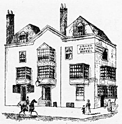
The building on the corner of High Street was, in 1860, the York & Pier Hotel though this hadn't always been it's name. It had formerly been known as the Grand Parade Hotel (see drawing, right). Of course, as one side faced High Street it does appear on the Charpentier guide (see below left), which seems to be much the same as in images from the 1860s. Using the map, the hotel appears to have frontage 43 feet wide on the Grand Parade side and 21 feet facing High Street. The height may be estimated by comparison to the adjacent buildings. A closer examination of the building shows it to have had a more varied history than many of its contemporaries. The general layout of the windows is rather haphazard, suggesting that it was probably constructed from two separate buildings, if not three. There are certainly three doors, one of which is plainly the guest entrance whilst the other two would have been for tradesmen and employees.
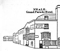
There is a particular problem with the bay windows, especially on the side facing High Street. In the upper drawing the draughtsman gives us only a hazy impression of the layout of the windows though he does seem to accurately portray the very low headroom to the door which is also shown in Charpentier. Given that the rest of the bays are rectangular in plan it seems reasonable to assume they are on the High Street side but this is not clear. Another drawing from the early 19C suggests that the lower bay has angled side components whilst a photograph from the 1880s depicts an altogether shallower rectangular structure. A degree of guess work will be required here.
As with the neighbouring building on Grand Parade the roof to the York and Pier Hotel is constructed with two differing angles of pitch, but in this case there are two entirely separate sections of roof, both utilising this broken roof line.
Documentary Evidence
Post Office Directory (1859) - Benjamin Hinton, 9 Grand Parade; William Hooker, Sun Tavern, Grand Parade; William Litchfield, 'Times' Correspondent, 9 Grand Parade;
Kelly's (1859) - William Hooker, Sun Tavern, Grand Parade; John Dickenson, York & Pier Hotel, Grand Parade
Harrod's (1865) - Mrs Elizabeth Hinton, 9 Grand Parade; Mr William Litchfield, 7 Grand Parade; John Dickenson, York & Pier Commercial and Family Hotel, Grand Parade; Mrs. Agnes Hooker, Sun Tavern, Grand Parade;
1861 Census
Schedule 195 - William Hooker (35, Victualler), his wife Agnes (36), sons William (8), George (6) and Alfred (1) with Henry Hazard (33, Servant), Sarah Pearce (18, Servant), Edward Burrows (22, Gentleman, visitor), Anne Burrows (10, visitor), Henry Smith (24, Gentleman, Visitor) and Caroline Smith (21, Visitor)
Schedule 196 - Benjamin Hinton (80, Retired Bookkeepers Clerk), his wife Elizabeth (80), daughter Emma (42) and Mary Ann Dapson (27, Servant)
Schedule 197 - William Litchfield (39, Press Correspondent), his wife Harriet (41), sons William (17) and Frederick (14), daughter Elizabeth (13), sons Alfred (10) and Arthur (5) and daughter Alice (4) with Louisa Tighe (15, servant)
Schedule 198 - Anne Willis Piercey (48, Widow), her sons Moses (14) and George (12)
Schedule 48 - John Dickenson (56, Hotel Keeper), his wife Anne (56) and son John (23) with Alice Beake (15, Barmaid), Victoria Taylor (26, Servant) and William Saunders (15, Servant).
We know therefore that William Hooker and family lived at the Sun Tavern and that by 1865 he was no longer present, his wife Agnes having taken over the tenancy. Next door were the Hinton family and beyond them William Litchfield and his family. The directories tell us that Litchfield lived at No. 9 which implies that the Hintons were at No.8. This in turn suggests that the Sun Tavern had by the time of the census taken over both Nos. 6 and 7. This scenario raises another issue as there would then be no property for Anne Piercey to inhabit as the York and Pier Hotel would have been immediately adjacent to the Litchfield residence at No. 9 and we know that John Dickenson was the landlord of the York and Pier.
An alternative interpretation may present itself in that the page of the census on which Schedules 195-198 appear also records a John Blackwell at the King's Arms and it is known that Blackwell was in fact the landlord of the former Crown Hotel at Nos 35/36 High Street, so plainly this page is being used to mop up households that were not recorded in sequence and if this applies to Blackwell it may also apply to Anne Piercey.
Under a further alternative, the Sun could have been No. 7 and not No.6 which would allow the Hintons to live in the gabled building, the Litchfields in the first of the modern houses and the Pierceys in the second at No. 10. Supporting this notion is the matter of whether the Hintons who were in their 80s and presumably living on a meagre pension could have afforded to live in one of the modern houses. There is no immediate resolution to this conundrum.
The fact that the Dickenson record is out of sequence (Schedule 48) is of no significance since the York and Pier details were taken as if the property had been on High Street.
Summary
The extension to the Guard House will be deemed to have occurred after our target date and therefore the model will portray it as it appears in the 1860 photograph and on the ground today.
The confusing evidence for the occupation of Nos 6-10 Grand Parade as presented by the directories and the census will have to be ignored in the model since even if the Sun had taken over the property next door it was not demolished by the time the photo c1870 was taken. The model will therefore show the gable ended house, regardless of who was living there. The two modern houses will be based on the general style used on High Street in this period whilst the York and Pier can be safely constructed using the available images as guides.