
No. 17-21 High Street
None of the properties from No. 17 to No. 21 High Street survive, though there are some tantalising clues on the ground. The modelling of them will therefore be based largely on documentary and photographic evidence. The obvious starting point is the Charpentier strip drawing of 1842.
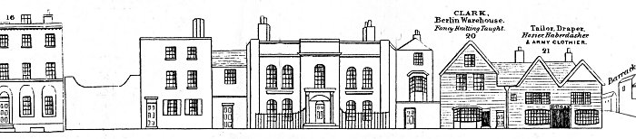
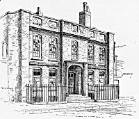
It is not known why Charpentier did not include the house numbers for 17 to 19, especially as there appear to have been four separate structures between No. 16 and No. 20 plus a large gate adjacent to No. 16 - possibly 5 plots for 3 numbers. Fortunately, the house at the centre, No. 19 is well known and there are several images in which it appears, as well as at least two verbal descriptions, one written by AT Everitt which is in the Bonham Carter archive at Hampshire Record Office, but which is currently misplaced.
The first record of a house on this site is on a map of Portsmouth, dated 1577. Near continuous records of ownership follow as the building changed hands on a number of occasions until around 1690 it was bought by John White who converted it into an inn called "The Antelope", but this role lasted only a few years. In 1761, William Pike the founder of the Pike Spicer Brewery purchased it though he seems to have preferred living in No.1 Penny Street, opposite to the brewery entrance. For most of the following years until 1910, when it was sold along with the rest of the brewery to Brickwoods, the house was occupied by various members of the Carter (later Bonham Carter) Family.
On New Year's Day in 1839, Edward Carter, six times Mayor of Portsmouth was in residence when a man named John Pounds knocked on the door. Pounds is perhaps one of the best known men of Portsmouth being the founding spirit behind the Ragged School movement, living close by on Highbury Street where his cobblers shop doubled as a school for poor boys. Carter was a supporter of the school and on this occasion John Pounds was calling to ask for help buying some ointment for one of his boys. Whilst waiting in the hall for Carter to arrive he collapsed and died almost instantly and passed into legend.
A second drawing by William Snape is of No. 20 High Street. This again is dated 1897 and this one too is plainly the same building that is shown in Charpentier but it differs in that it is shown as a separate building whereas in Charpentier it is only half of a building that includes No. 21. The 1860 OS map suggests that the same single building continued to occupy the whole of that area so No. 21 must have been demolished between 1860 and 1897. Records show that a fire occurred in the brewery in 1864. This may have involved No. 21 but there is no known confirmation of this.
It is interesting to note that in the background of the drawing is a part of No. 19 that is set back from the pavement and not visible in either image of the house above. The first floor bay window is particularly evident.
At this point there was no further evidence to guide the modelling of Nos. 17 and 18 as they appeared in 1860.
There is however, some help we can call upon, in the form of the Pike Spicer brewery map mentioned earlier. Although we have no precise date for the map it is unlikely to be before 1879 as it mentions the Borough Gaol with the legend "About to be demolished". The Gaol was superceded by Kingston Prison in 1879/80. It can, nevertheless, offer some clues.
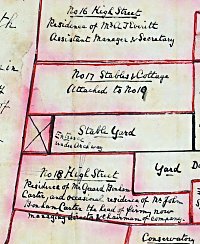
The map shows No. 17 with the inscription "Stables and Cottage - attached to No.19", below which is a separate area labelled "Stable Yard" with an arched entrance from High Street and then No. 18 described as the residence of Mr Gerard Bonham Carter, a member of the family that owned Pike Spicer.
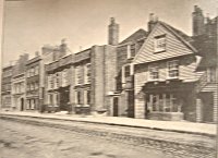
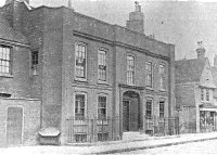
There is a final piece of evidence in the form of a photograph showing Nos. 16-20 High Street, taken from the end of Highbury Street. It comes from a copy of part of a book entitled "The Noted Breweries of Great Britain and Ireland, 1891" by Alfred Barnard, held at the Central Library, Guildhall Square. It is the only picture so far discovered showing numbers 17 and 18 High Street but sadly the probable date is too late to be of use in this phase of the project as neither building bears any relationship to the houses on the Charpentier drawing or the brewery map, both of which precede it in date.
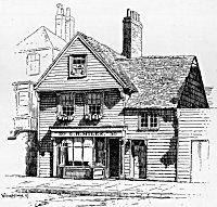
Number 18 is less of a problem in that the Charpentier drawing gives us a good idea of how the frontage looked. As it happens it is very similar to some of the houses on the other side of the road at the time and it seems that in the absence of further evidence we could use No. 127 High Street as a guide, though the whole building would have to be reversed left to right and the windows would have to be adjusted slightly to accord with Charpentier.
All images are copyright © Tim Backhouse. Click on the thumbnails for full size versions.
Project Considerations
The lack of any detailed information about the buildings on the plot numbered 17 will make it extremely difficult to place an accurate structure there. There seems little alternative but to leave a gap in the model and continue the research in the hope that something turns up.
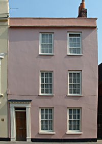
127 High Street - reversed
Self-evidently the grandest house so far encountered, No. 19 will require some special modelling. The doorway in particlar appears to be most sophisticated in having what appears to be a circular vestibule with a scalloped ceiling in front of the door itself. We also encounter a basement floor, partially below ground, and two extraordinary columns with large, concave chamfers at each side of the main structure.
The two flanking extensions to No. 19 will be a little more awkward as they both have retaining walls immediately in front of their ground floors which won't therefore be visible from street level (unless the door in the wall is left open).
The evidence available for modelling for Nos. 20 and 21 was limited. The Charpentier drawing gives a good overall impression of what the buildings looked like, but there was initially some doubt that No. 21 still looked the same in 1860. We knew that at some point before about 1880 this building had been replaced by the Connaught Hotel (see Pike-Spicer map). Luckily the Simpson's Directory of 1863 gives the following information, "Dugan M. P. and G. outfitter, army clothier and haberdasher, 20 & 21 High Street". This is the same name that appears over the door to No. 21 in the Charpentier drawing. We can therefore be confident that No.21 had not altered significantly between 1842 and 1863.
There remained however some suspicion that the Charpentier drawing is less than accurate. From three maps and other drawings an average of 52 feet for the width of the frontage of Nos. 20 & 21 was established and this gave some idea of the heights involved, but scaling up the shop fronts gave a result of around 6 feet for the height of the doorways which did not seem likely, especially when compared with surrounding buildings in the photographs. Eventually a compromise had to be found, so the accuracy of the resulting model is probably no better than about 85%. A final problem with No. 21 is that it also has a frontage onto Barrack Street and for this we have no evidence, as yet. This aspect of the model is at present wholly speculative.
There is a further problem which will affect all of the buildings we recover by research, namely their colour. In most cases it will be almost impossible to state accurately the materials used in their construction. All we can do is compare and contrast with the buildings we do have, including taking monochrome photographs to mimic the effects on the documentary evidence. At end it will be a best-guess solution.
Snapshots from the Model (Nos. 17-21 High Street)
![]()
![]()

Old Portsmouth Model Images
THE 1860 PROJECT NAVIGATION