Battery Row
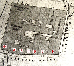
As soon as we look at Battery Row from a historical perspective we meet with a problem. The road we know by that name today runs from the Square Tower towards Grand Parade with the buildings on one side only, facing south-west. On the 1861 map (see right) however, this stretch of road was known as Semaphore Place, presumably named after the semaphore station that stood on top of the Square Tower and which was demolished in 1848. Possibly it was previously known as Battery Row, especially as it faces directly onto the Saluting Battery which is a very old feature. However, the map shows that the name Battery Row was not entirely forgotten as the road at right angles to Semaphore Place, overlooking the Guard House on Grand Parade, had retained the name. For the purposes of the project we will adopt the nomenclature of 1861.
A more difficult issue to resolve is that of the numbering of the buildings along Semaphore Place, the map giving us no direct assistance in this matter. Normally we might expect that the numbers in use today would give a strong indication as to the system in use in 1861, but this cannot be taken for granted. The Victorians had no qualms about renumbering streets.
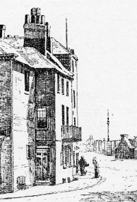
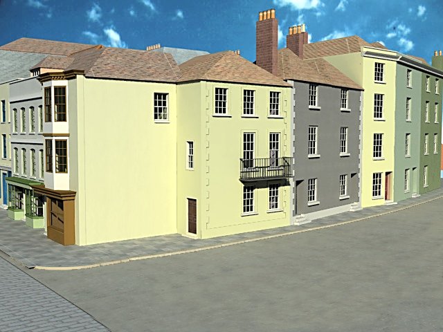
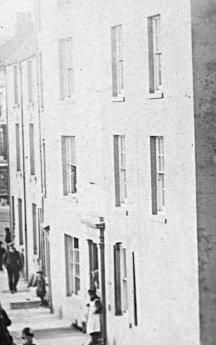
The building labelled A on the map is today known as No. 1 Battery Row. It has an elegant doorway on the south face, diagonally beneath a balcony, and fine decorated quoins. This is at odds with the image on the left which shows that no such door existed in the late 19C when this drawing was made. The south facing door is in fact a much later development and may even be post World War 2 - there is certainly a photograph from the late 1930s showing that it had yet to be installed. Further supporting evidence can be deduced from the near pristine condition of the decorated quoins indicating a relatively recent conversion. Prior to this the main door was on the side of the building, facing west, as can be seen on the drawing, but this in turn was not the earliest configuration.
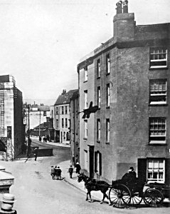
The 1861 map shows that the structure we now know as No.1 Battery Row was part of No. 64 High Street; the west facing door then being a window, as can be seen in an early photograph (see bottom, right) looking through the main arch of King James Gate. This revelation helps to resolve another issue, one that cropped up during the research on No. 64 High Street. Documentary evidence showed that in 1860 the resident at No. 64 was Vincent Pappalardo who amongst other professions was the Consul for Italy, Spain, the USA and other countries and yet the building seemed improbably small for such an esteemed person, it being no more than 15 feet square. If, however, the property included the next building in Semaphore place then it would have been of a more appropriate size. [Further information on this matter came to light in 2011 when a correspondent mentioned that his mother lived in No. 64 in the early 20C. She belonged to the White family and her father was a Trinity House Pilot. The large family also occupied the house next door in Battery Row.]
Moving along the modern Battery Row we note that the buildings labelled B and C on the map are today combined into a single property - No. 3 Battery Row and that there is no No. 2 Battery Row. These numbers would be expected once No. 1 had become an independent dwelling but before that time they should have been Nos 2 and 1 respectively. Similarly, the buildings labelled D and E are now respectively Nos. 4 and 5 whereas perhaps they were originally Nos. 3 and 4. The last building on the block, labelled F, now has no entrance from the Semaphore Place side, but may well have done so originally as can be inferred from the drawing on the right which also suggests that it could have been combined with property E in the early 19C, the "Billiards" sign extending across both properties.
There are no clear frontal photographs of the buildings in Semaphore Place from around the 1860s, but we can be fairly sure that they would have had dimensions similar to those of todays structures. Their facades have been altered a great deal since WW2 as they became much sought after dwellings but their footprints match those in the 1861 map so it would not be unreasonable to assume the heights are also similar.
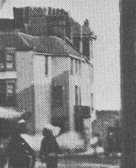
We do have some further images of the east end of Semaphore Place such as the example from around 1925 on the left. Both this photograph and the drawing above show the buildings labelled E and F and, moreover, shows them to have been essentially the same structures. We can therefore be confident that this was how they appeared in 1860.
We can use the 1925 photo to confirm the relative heights of almost all the buildings in Semaphore Place, for although they are depicted from a most acute angle there are some useful clues. A second version of the photo (below, right), shows building E on the right and by examining the line of it's cornice it can be seen to continue, albeit at a different angle beyond the left wall. Although we cannot see building D from this angle we can surmise that the continuation of the cornice defines it's height which must be almost identical to that of building E.
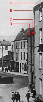
The same process can be used to determine the heights of buildings B and C, but in this case it is the line of the second floor window cills which, on projection, reach building D a foot or so below the corresponding window. The front faces of all three buildings are on a similar orientation and so any distortion due to perspective should be minimalised.
From this photograph, and the one taken in 1911 (bottom, left) we can just make out that each of B and C has a single window at each floor level and that doors are sited away from the common centreline. These two are grouped together as they were plainly built as a pair and are mirror images of each other. This can be confirmed from the buildings that survive today on which it can be seen that there are decorated quoins on one side of each building only. To the left on B and to the right on C.
The south facing sides of buildings E and F are so similar that they too were probably built as a pair, if not as a single building as is suggested in the drawing above from c1800. When we come to the east facing side of building F though we note some unexpected changes to the layout of the windows which on the left side continue the size and positioning of those on the south side but on the right hand side there are two much narrower windows at each level suggesting that the building was formerly constructed in two stages, probably representing two dwellings. This can be seen in the photo of Victoria Tavern from the 1880s below.
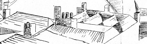
The roof structure of building F is rather interesting, that is if Commander Smyth depicted it correctly in his 1824 drawing (see left) from the top of the Semaphore Tower which in turn was perched on the roof of the Square Tower. It consists of 4 small gables running from west to east, all of which terminate in a long gable across the eastern side.
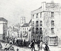
The final building in this section is the Victoria Tavern, the best available evidence for its appearance coming from an extract of a photo taken from King's Bastion, probably in 1880s, after the Guard House has been demolished (see right).
This photograph gives a good idea of the size of the Victoria Tavern, indeed it is so large that it seems unlikely that it would have been solely a drinking house, rather it would serve perfectly as lodgings, if not a hotel. Much of the structure of the Tavern can be deduced from this image, but the ground floor will be more problematic. There are certainly bay windows at first floor level and these may have been carried down to the ground floor, but equally one of them could be a door with a pediment and columns either side. As the Victoria Tavern is not mentioned in the directories after 1863 the facade may well have been modified to accommodate a new status as private residence by 1880.
Documentary Evidence
The contemporary directories provide the following information:-
Post Office Directory (1859) - Arnoldus Louis Van den Bergh at Battery House, Semaphore Place; James Neale at Victoria Tavern, Battery Row; George Richards, pilot, Battery Row
Kelly's (1859) - James Neale, Victoria Tavern, Battery Row.
Simpson's (1863) - John Coote, 4 Battery Row; William Main, 3 Battery Row; Mary Neale, Victoria Tavern.
Harrod's (1865) - Mark Charles Barron, Master Mariner, Semaphore Place; John Coote, Pilot, 4 Semaphore Place; Mrs. Field, lodging house, Semaphore Place; Van den Bergh also appears though under his official address in Bath Square.
The 1861 Census does not specify the street numbers for Semaphore Place but records the residents under five schedules:-
Schedule 189 - Mark Charles Barron (32, Mariner) with his wife Mary (28) and Nephew James Barron (14)
Schedule 190 - William Main (32, Pilot) with his wife Emma (29), sons, James (11), William (9), Henry (4) and John (0) and daughter Emma (6).
Schedule 191 - John Coote (46, Pilot) with his wife Elizabeth, sons James (18) and John (11) and daughters Louisa (15), Emma (14) and Elizabeth (8).
Schedule 192 - George Richards (46, Pilot) with his wife Elizabeth (43) and a servant Charlotte Douglas (21)
Schedule 193 - Arnoldus Louis Van Den Bergh (31, Consul Merchant, employing 6 hands) with his wife Louisa (30) and sons Louis (7), John (5), Adalbert (4) and Lucy (2) with daughter Hermina (0). Two servants Ellen Savage (18) and Jane Strong (24) were also living in the household.
For Battery Row there is only one entry, namely the Victoria Tavern:-
Schedule 194 - Mary Ann Neale (42, widow) with her married daughter Sarah Ann Northover (22) and grandsons George James Richards (6) and James George Northover (4) with a servant William Hooker (43).
Summary
As far as the model is concerned there is little need to determine the correct numbering of the houses in Semaphore Place; we already have sufficient evidence to enable accurate copies of the buildings to be created. This of course would be to disregard a fascinating insight into the development of the town around the south end of the High Street. Of some interest is the observation that according to the census Semaphore Place was largely occupied by men of the sea. With three adjacent properties all occupied by Pilots and another by a Master Mariner there is a suggestion that perhaps they were owned by a man or company closely associated with trade in the Camber. There are several obvious candidates, perhaps further research could establish the owner.
Also of interest is the fact that the four seamen's houses are sandwiched between two important Consuls, Merchants and Shipping Agents, Vincent Pappalardo at 64 High Street and Arnoldus Van den Bergh at Battery House, the latter being taken to be the building on the corner of Semaphore Place and Battery Row. We might wonder why such wealthy and influential men should choose to live among lowly seamen, but perhaps we are underestimating the regard in which mariners of such standing were held.
Returning to the issue of house numbers, we note that the Census has only four schedules for Semaphore Place (five if we include the Van den Bergh family), whereas there are five properties (not including Battery House). This is primary evidence to support the notion that building A on the map above was, in 1861, a part of No. 64 High Street. The only other possibility was that at the time of the census one of the properties was unoccupied.
Less easy to interpret are the house numbers quoted by Simpson's Directory which places the Main family at No. 3 and the Coote family at No.4. Harrod's Directory confirms the latter. In the census the Main family are the second family unit listed and the Coote family the third and so logic would suggest that they lived at Nos. 2 and 3 respectively. If however they did live in the buildings labelled C and D on the map then we would have to conclude that building A, although part of the household associated with 64 High Street, retained it's own identity as No. 1 Semaphore Place. This could only be resolved by further research.
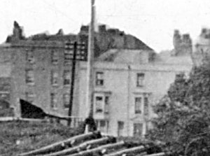
The heights of the buildings on Semaphore Place can be largely determined by looking at the photo (below, right) which was taken looking through the central arch of St. James Gate. Here we can see that building A is the same height as 64 High Street which has been set by comparison to adjacent buildings on High Street. The same image can be used to deduce the heights of buildings B and C which are about a foot taller than A. D and E can be compared to B and C using this same image or the ones above.
The image on the right is the only one which appears to show that building A has a window in the west facing wall. It is partially hidden by a white cloud, but there is a definite trace of a lattice. The photo which is not specifically dated does not, however, tell us when the window was converted to a door. For the purposes of the model we shall assume the door was present. It follows from this and modern observation that the door in the south face and the quoins will not be shown.
From the available evidence it seems that all the buildings so far examined were of a plain, simple design with only minimal decoration, such as the balcony to building A and the quoins to buildings B and C. The south facing walls were exposed to the prevailing weather and as they were situated just a few feet from the sea were probably difficult to maintain. This is especially apparent with building F in the 1925 photo which shows considerable irregularity in the render. The model will take account of the fact that in the 1860s this was the home of a wealthy man who could probably have afforded to keep it in good condition.
In contrast to Van den Bergh's fortunate circumstances, his neighbour, Mary Ann Neale in the Victoria Tavern was having to come to terms with the death of her husband James who must have died quite recently given that he was listed as landlord less than two years earlier. The evidence for this is in the census which shows that no guests were in residence. If James had died very soon before the census it may be that Mary was still in mourning. At any rate she didn't stay long at the Victoria for although it appeared in the 1863 directory, by 1865 it was no longer listed.
The photograph from the 1880s above will be used as a guide to the modelling of the building, but it will be difficult to re-create it exactly. The information concerning the upper floor windows is excellent but the ground floor is imprecise and in any case may have been modified following conversion.
Additional Information
Arnoldus Van den Bergh followed in the family tradition when he succeeded his father as Consul General of the Netherlands, in Portsmouth. He was born in Portsmouth on July 27, 1830 and married Ann Louisa May, born February 2, 1831 in London, on April 13, 1853 in London. There is an extensive Van den Bergh family tree at www.camerama.demon.nl/bergh/
All images are copyright © Tim Backhouse. Click on the thumbnails for full size versions.