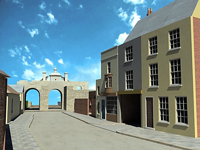
Nos. 65-66 High Street, plus the Guard House
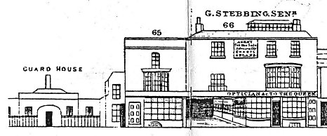
The west (or more accurately north-west) side of High Street begins at King James's Gate, then, passing first the entrance to White Hart Road the first building encountered is the Guard House which completes the military complex at this important point in the fortifications. As we might expect, a drawing of the Guard House appears at the end of the Charpentier Panorama (see right) alongside depictions of Nos. 65 and 66 High Street which in 1842 would have been shops and dwelling houses. As shops they were well placed in terms of their position inside the gate but they were some distance from the fashionable centre of High Street.
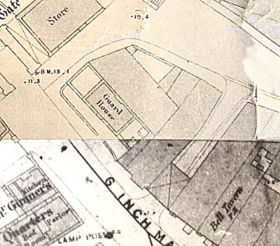
The Charpentier drawing also shows a curious, low, narrow building to the left of No. 65 but gives no indication whether it is part of that property or if it should be considered part of the Guard House. The 1861 OS Map of the area (see left) offers no further help in this matter. Charpentier is more helpful when it comes to No.66 which it informs us was the property of G. Stebbing Snr., and includes the legend above the shop "Opticians to the Queen". A further notice on the facade tells us that Stebbing was "Agent for Military Charts and Maps". A biography of George Stebbing appears in the People section on this site.
Of particular interest when examining the drawing of the shop is the left hand section which appears to be an arcade stretching back into a dark void. The 1861 map confirms that this void extended all the way back to White Hart Road, but there is no indication why such access would be required when the entrance to that road was only 50 feet away. It may be significant that the void is directly opposite the Sally Port and would have afforded rapid access to the ship building area on the Camber.
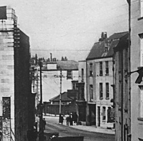
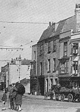
There are no known photographs of the High Street side of these buildings from the 1860s but we are not entirely without photographic evidence as this section of High Street appears in the background of at least two images taken from east of the Square Tower, looking down Semaphore Place/Battery Row (see right and below, bottom). The photographs are undated but are probably pre-First and pre-Second World War, over 50 years after our target date. Nevertheless, they show the Guard House and both Nos. 65 and 66 in much the same structural format as they appeared in 1842. This is not unduly surprising in respect of the latter two buildings but the survival of the Guard House to such a late date is revelatory. There seems to be no reason why it should have stayed in place so long after the demolition of King James Gate which was it's raison d'etre. It may have inherited some alternative purpose.
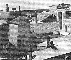
We are fortunate that the photographic evidence does not end with the two images seen thus far and the reason for this is that this area is in a direct line between the Cathedral (St. Thomas's Church) and the harbour entrance and over the years enterprising photographers have used the church tower as a location for panoramic images of the harbour. Of course it is only the rear side of the properties that face the church but the high angle affords the sort of detail that has not been encountered to date and this is particularly relevant in that these properties span the full distance between High Street and White Hart Road.
The two photographs are almost identical in composition but differ significantly in date. The first, a fragment of a photograph from 1864 can be seen on the left. This shows the back of King James Gate on the right with the Guard House in the centre and the rear of No. 65 and part of No. 66 on the left. This image seems to show that there is an open courtyard at the back of the Guard House surrounded by a high brick wall though there is no obvious point of entry to this area as the back wall of the Guard House is featureless apart from one window. At the rear of No. 65 there is a secondary building which may be detached as it has its own roof. Alongside this building there appears to be the exit point for the access way from High Street. The rear of No. 66 rises to three stories with what may possibly be a bay window at ground level. The buildings in the foreground would have been part of the Camber ship building operations.
Documentary Evidence
The 1861 Census lists James Deis (Gunner with the Royal Navy, aged 44) and his wife Elizabeth (36) as living at the Guard House. It is perhaps surprising that anyone should consider their marital home to be in a military building such as this; further investigation may throw more light on the matter.
The subsequent entry in the Census records David Levy (62), his daughter Rebecca (21) and a servant Jane Lockhart (24). As the Census did not record house numbers we must assume that this relates to No. 65 but there are two grouped entries after it which may relate to the narrow building between No. 65 and the Guard House and/or the isolated building at the rear of No. 65. The first was for Eliza McConnell (29, married, Wife of an Artillery Man), her daughter Eliza (3) and son Alfred (1) whilst the second was Bridget Bougherty (20, married, Wife of an Artillery Man) and Robert Bougherty (31, undefined).
David Levy was in 1860 an Alderman of Portsmouth Borough Council. The Post Office Directory of 1859 gives No.65 as his private residence. He died in March 1862. Unlike other residences of Aldermen on High Street, No. 65 seems to be rather modest especially as the Rent Rolls of 1861 show Levy to have leases on several encroachments on High Street, one of which refers to The Bell public House, two doors away at No. 67.
We know from the Charpentier drawing that in 1842, No. 66 was the rather elaborate shop belonging to George Stebbing. He died in 1847 after which his widow Charlotte seems to have sold the business but retained an interest in the property as the 1861 Rent Rolls list her as owning the lease on "Land, dwelling-house, shop and work-shop, near the Guard House, north side of the street", which had been granted in 1694 for 1000 years. Charlotte herself must have moved from the property before 1861 as the Census gives the Head of Household as John Davies (34, Beer Retailer) who was living with his wife Harriett (35) and 9 lodgers and servants.
Simpson's 1863 Directory lists William O'Neil as running a General Store at No. 65 whilst the Harrod's Directory of 1865 records George Diamond, newsagent and French polisher as living at that address. None of the directories list anyone at No. 66 which may be indicative that by 1860 it was a private dwelling. If this was the case then the structure we see in the 1910 photograph was probably in place in 1860 rather than the original version we see in the Charpentier drawing of 1842.
Summary
The information regarding the Guard House is difficult to assess as it appears to have slightly different structures in each of the drawing, the map and the photographs. In the Charpentier drawing the building shown seems too wide to fit into the available space given that the frontage of the Guard House is only 32 feet. It is also at odds with the 1861 map, in that it shows two "wings" either side of the main block where the map shows what appear to be open courtyards, the right hand one possibly containing two urinals. Also, Charpentier shows a building surrounded by railings whereas the map indicates a much more substantial brick wall and this is supported in the photographs from the 20C. The rear of the Guard House is even more confusing, a matter that is not resolved by the photographs. As there is no information about the front elevation of the Guard House in 1860 the model will show the central block as defined by Charpentier with the courtyards and brick wall surround from the map.
Between the Guard House and No. 65 lies the very narrow two storey building, barely 6 feet wide. It has a very low elevation in comparison to the main building, perhaps no more than 16 feet high. Whether it is to be considered part of the Guard House or No. 65 is irrelevant as far as the model is concerned.
No. 65 appears much the same in Charpentier and the 20C photographs with a few modifications at ground level though the photographs are too indistinct to offer much assistance. According to the 1861 map it has a width of around 16 feet. The photo of the front offers no clues as to the form of the roof but the one of the rear tells us that the middle section of the building has a gabled roof with dog-legged sides.
The arcade to No. 66 in the Charpentier drawing can be taken as having been converted into an alternative route through to White Hart Road by 1860 if it hadn't always been so but this is slightly complicated by the apparent absence of any means of access to the rooms above the void. Originally they would have been a part of No. 66 and accessed from that side of the building but by the time of the 1910 photo there are different colours on the facades of both sections suggesting that they were separately owned, though this may be accounted for by a slight change of angle in relation to the right hand section of the house.
The roof to No. 66 presents it's own problems. The photo from around 1935 indicates that there was another dog-legged gable at the front of the building; it begins rising steeply but then flattens out slightly. However the photo from the rear clearly indicates that the back slope of the roof has a single gradient, at a lesser angle than either on the front. At present we cannot say whether each side of the roof had a different structure in 1860 or not. This photo does on the other hand give us clear evidence for the roof structure on the rear section of the building.
According to the 1861 map the frontage to No. 66 measures 31 feet in width (including the void). As usual we have no information of the height of the building, given that we cannot rely on Charpentier, so an estimate of 26 feet to the top of the parapet will be used until further evidence is forthcoming.
All images are copyright © Tim Backhouse. Click on the thumbnails for full size versions.