
Nos. 25 - 29 High Street
None of these buildings exists today, so our primary evidence will be the Charpentier drawing and the OS 1:500 map of 1861. Fortunately the buildings were close to the George Hotel and many of the photographs of it were taken at an oblique angle and included the buildings close to it. Some evidence can be obtained by careful examination of them and two other images from north looking south.
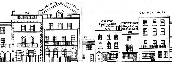
No. 25 was designed and built by Thomas Ellis Owen in 1840 for Edward Casher, three times Mayor of Portsmouth. It was later described by Ubsdell, a local artist, in a letter to the historian, Sir Frederick Madden, as 'a very fine building'.
Charpentier ascribes No. 26 as the Portsmouth Branch of the Bank of England but interestingly the archive of the Bank of England states that the Bank was opened at 26/27 High Street on 16th May 1834 and moved to 109 High Street in 1839. Charpentier also records the occupants of Nos 28 and 29, the former being a hair cutter by name of Crew - could this have been the origin of the 'Crew Cut' - and the latter a boot and show maker called Silverlock.
The second important source of information comes from the 1861 map in Portsmouth City Museum and Records Office. A tracing of the relevant area appears below. Again we see that No. 26 is designated as the Bank of England. It also shows a gap to the left of No. 26 with the adjacent building which corresponds with No. 27 on Charpentier being set further back.
The map allows us to measure the widths of the buildings. These are 21'0" (No 25), 38'6" (No 26), 16'0" (alley to No 27), 23'0" (No 28) and 16'0" (No 29). Some of these dimensions differ wildly from the impression given by Charpentier. The actual widths show No 26 to be almost twice the width of No 25 whereas Charpentier shows it to be perhaps 25% wider.
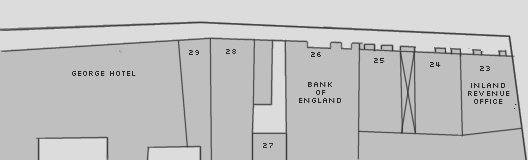
One possible conclusion is that the curious foreshortening of No. 27 in Charpentier is a deliberate attempt to convey perspectively that the building is at the end of an alley. If this is correct, then an explanation is needed as to why there appear to be 3 buildings between the gap and the George Hotel where only two (Nos. 28 and 29) are supposed to exist. It is time to start looking at the available photographs and drawings.
The three images below represent some good evidence for the overall scene at this point on High Street. In all three cases the view is northwards with the George Hotel on the extreme right.
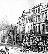 Drawing mid 19C | 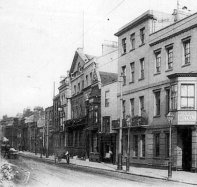 Photo c1910(?) | 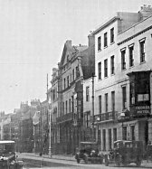 Photo c1925(?) |
In all three the pediment of the former Bank of England (No. 26) is clearly discernable and had plainly remained much the same since the Charpentier drawing was completed. The same can be said of No. 29, adjacent to the George Hotel, and No. 25, beyond the Bank. It is unclear what is happening between the Bank and No. 29. This can be partially resolved by looking at a postcard from The Wrench Series (No. 6106). This series began in 1900 and continued for around 20 years, publishing well over 16,000 cards in the process. Assuming they were numbered in the order they were released and the total number were spread evenly over the 20 years then our card would have been issued around 1908. This image shows the scene as viewed from the north.
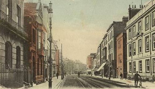
The former Bank of England can be readily recognised as the building on the left - the window format is the same as in Charpentier. On the right is the Governor's residence and Charpentier tells us that is opposite Nos. 28-29. Also shown is the building next to the Bank which appears to be a red bricked two storey structure with an elaborate pediment (the same building shows up on the two photographs from the south) but there seems to be no space for any alleyway through to No. 27.
Closer examination of the photos from the south show that beyond the red-brick building there seems to be a section of a structure which although projecting out further than No.26 is built using the same construction lines, cornices, window heights etc. as No. 26. It is also partially obscured by the red brick building and is therefore set back a little. A possibility is emerging that the alleyway was converted for use of an extension to No. 26 and that the portion of the Bank that is visible in the Wrench image is in fact the extension and not the main building. Support for this notion is seen on the extreme left where the beginnings of a railed entrance way can be seen at exactly the point where the original door to the building would have been sited if this was the extension.
In further support of this conjecture it can be seen from Charpentier that the original bank building was flanked by two substantial columns, but the postcard from the Wrench series shows no evidence of the southern column. Althought this development is fascinating it does not help us to understand the structures in 1860 since a map from 1898 shows that there still remained a gap on the south side of No. 26 which suggests that if the theory of an extension being built onto the bank is correct then it could not have happened earlier than that date. However, further evidence of the sequence of construction around 1860 can be seen in a drawing from the middle of the 19C.
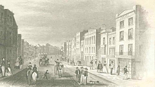
Here we see on the right the Comerfords Bookshop which Charpentier tells us is opposite No. 25. A little further down is the Governor's Residence. On the left the two bold columns of the Bank can be matched to their counterparts in Charpentier, though the bank itself is concealed by the northern column. The drawing also shows that No. 25 is standing a couple of feet proud of No. 24.
Unfortunately we are left with no evidence apart from Charpentier as to the nature of No. 28, nor of the curious structure on the south side of the alleyway.
Documentary Evidence
The Trade Directories from the period 1852-1865 offer the following information:-
Hunt's (1852) Directory - Mary Ann Dixon, straw bonnet maker, 27 High Street; John George Dixon, carpenter, 27 High Street; Fanny Crew, artist, 28 High Street; William Crew, hairdresser and toy dealer, 28 High Street;
Post Office (1859) Directory - Bank of England, John Henry Dorrien, agent, John Henney, sub agent, 26 High Street; Fanny Crew, miniature painter, 28 High Street; Edward Crew, engraver, 28 High Street;
Kelly's (1859) Directory - Bank of England, John Henry Dorrien, agent, John Henney, sub agent, 26 High Street; Edward Crew, engraver, 28 High Street; William Crew, hairdresser, 28 High Street;
Simpson's (1863) Directory - Edward Crew, engraver, 28 High Street; Richard Pierce, surveyor of taxes, 28 High Street;
Harrod's (1865) Directory - John Henney Esq., 25 High Street; Henry John Dorrien Esq., 26 High Street; Bank of England, Henry John Dorrien, agent, John Henney, sub agent, 26 High Street; Edward Crew, Fancy Repository and Archery Warehouse, 28 High Street.
1861 Census
Schedule 16 - John Henney (71, Bank of England sub-agent), his wife Sophia (61) with Caroline Grenyer? (20, servant)
Schedule 17 - Henry J. Dorrien (59, Banker), with servants Elizabeth Hurst (59), Ann Hurst (38), Sarah Watkins (15) and stable servants William Borroman (32) and George Soper (18).
[Between Schedules 17 and 18 are the words "A piece of waste ground"]
Schedule 18 - Fanny Crew (55, Teacher of French), her brother Edward Crew (47, engraver), her neice (Caroline Barber (24, Assistant in the shop) with servant Elizabeth Oxford (50).
Schedule 19 - Thomas Cousins (28, Attorney and Solicitor)
Schedule 20 - Charles Fowler (34, Captain, Royal Engineers) and servant John Morton (47).
The Census enumerator for this section of High Street was unusual in that he included the house numbers alongside the schedules. Thus we can be certain that the schedules represented Nos 25 to 29 High street, the only anomaly being schedule 19 which was not ascribed any number. There is no indication whether Thomas Cousins was living at No 28 or 29, but either way he would probably have had self-contained accommodation. The indication concerning the waste ground is useful as it confirms that the Bank of England had not been extended over the alleyway to No 27 by this date.
There is some further information that can be gleaned from this evidence, one item being the presence of a shop assistant in the Crew household. Neither Edward nor Fanny Crew were likely to have needed a shop but the census return actually shows a Henry Crew as Head of Household with his name crossed out and Fanny's inserted. This may mean that Henry was operating a shop, possibly a hairdressers, but was absent on the night of the census.
The other piece of evidence is the existence of two stable servants in Henry Dorrien's household. This may indicate that the land, formerly assigned to No. 27 was being used as a stable. This was rather uncommon on High Street and suggests that Dorrien's standing was significant. It may be no more than a coincidence but a Governor of the Bank of England from 1818-1820 was a George Dorrien. The connection may be quite relevant as there was a John Dorrien merchant banker and a forerunner of the RBS Bank was known as Dorrien, Magens, Mello & Co.
Project Considerations
The single most awkward aspect of modelling High Street between Barrack Street and Pembroke Road is that no two maps agree on the frontage widths of the various properties. Two buildings still exist and we can measure their respective frontages but none of the maps or Charpentier agree with their actual relative sizes. The one measurement that cannot be changed is the distance between Barrack Street and Pembroke Road and this turns out to be 423 feet. It is with some guesswork that the widths of all buildings has been estimated to fit proportionately within that reach.
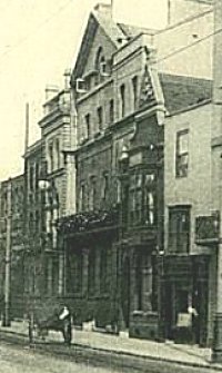
No. 25 will have to be taken almost entirely from Charpentier but with a little help from the photograph (right); similarly, No. 26 can be based on the drawing but with a little additional help with regard to materials from the photographs; the extension to the bank will have to be omitted since the 1861 map shows it is not yet in place. No. 27 will therefore be modelled as being sited some way back at the end of the alley.
No. 29 can be mapped from the photographs though the shop front seems more elaborate in them than in Charpentier. This leaves No. 28 which is plainly different in Charpentier from the later photographs. The red brick building looks to have been a handsome structure which would have been a pleasure to model but the evidence from the map suggests that it did not exist in 1860.
Postscript
Having rendered the model for Nos. 25-29 (see below) it is apparent that there is a discrepancy in the way that the flanking columns to No. 26 have been treated. The mid 19C drawing above shows them standing some distance beyond the front of No. 25 which accords with the photographs from the south show though to a lesser degree. This may require further research.
All images are copyright © Tim Backhouse. Click on the thumbnails for full size versions.
