The following article is based on "Excavations at Oyster Street, Portsmouth, Hampshire, 1968-71" by Russell Fox and K.J. Barton with a contribution by Margaret J. Hoad (Reprinted from POST-MEDIEVAL ARCHAEOLOGY No. 20 1986) and written with the assistance of Russell Fox and Portsmouth City Museum.
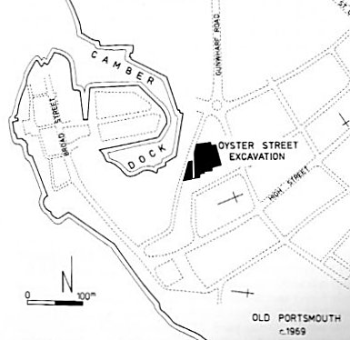
In 1968 the area around Oyster Street in Old Portsmouth was being re-developed and this allowed an extended archaeological excavation for the first time. The site was important because of its location on the waterfront of the original medieval harbour at Portsmouth. The aim of the excavation was to uncover evidence for the earliest permanent settlement in this part of town and although the ground was found to be much disturbed a sequence from 12th/13th centuries to modern times was recorded. There follows a summary of the evidence derived from stratigraphical and structural remains, ceramics and other finds.
The earliest datable evidence proved to be pottery from a 13th-14th century layer but beneath that there were features cut into clean gravel. These consisted of beam slots or gulleys, post holes, hearths and a rectangular depression, interpreted as representing the remains of at least two permanent buildings and several temporary structures. It was apparent that immediately prior to the 13/14th century layer the site had been levelled, severely disturbing previous occupation remains in the process. Small spoil heaps were discovered, one of which contained prehistoric worked flint.
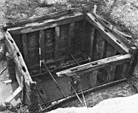
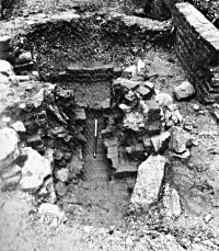
Following the levelling of the site, the late 13th century saw the construction of a complex of buildings and other features including pits, a well and a water cistern. One building measured 15m x 8m and substantial sections of its metre thick walls survived, some up to 0.5m high. At the time of it's construction the west face was only 5m from the high water mark along the east side of the Camber. One of the wells had a construction pit of 2.25m in diameter and was substantially built of random-sized limestone blocks forming a shaft of 1.5m diameter and 3.75m deep. Dateable finds from the well comprised mid to late 14th century, locally made pottery including jugs, pitchers and cooking pots. The cistern seems to have consisted of a rectangular pit measuring 4m x 6m lined with timber piles and cut to a depth of 6m to obtain fresh water from beneath the underlying clay levels.
The 14th and 15th centuries saw a period of consolidation and expansion. Existing buildings and other structures were improved and a formal quay and docking area were constructed. The main building from the 13th century was extensively modified with the addition of a 2m corridor on its west side, facing the prevailing wind. Further east was a garden area of loose soil measuring 10m x 13m. The soil was up to 30cm deep and contained a mass of domestic rubbish including animal bone and sherds of local late medieval coarseware pottery. The cistern, noted above, had a long and complex history in three phases. The first was a sheer sided rectangular pit revetted with tree-trunk piling to a depth of 5m; the second was lower and had a heavy oak framework 3m square set into natural clay 7m below the contemporary ground level. The frame timbers had mortice and tenon joints and an outside cladding of horizontal planks. It was of rough construction suggesting a hurried installation. The third phase was above the second and more carefully prepared. It was 3.5m x 3m and 2m deep and was covered by a floor of planks with 10cm gaps between. The central area was left open, presumably to allow the drawing of water.
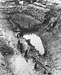
The cistern seemed too large to be simply for the use of nearby inhabitants and it seems more likely that it served as part of the victualling base for the docks discovered 20m south-west of the main building complex. The dock was 6m wide and at least 8m in length. It's walls were made of wattle up to 1m thick, comprising of upright stakes and, between, interwoven branches and twigs of hazel. A 25cm square oak post had been driven into the gravel outside the dock, possibly as a mooring point. There was no dating evidence from the backfill but from the stratigraphy of the area it appeared to have been abandoned early in the 16th century.
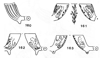
At this time the area around Oyster Street is losing its commercial role and reverting to a predominantly domestic function. Not only have the docks been levelled but reports tell of store houses between Lombard Street and Oyster Street falling into ruin. The only building to survive the changes is the original 13th century structure which remained essentially unaltered well into the 16th century, though for the first time red and yellow brick are in use. Around this building a number of other structures were exposed, a domestic oven, a forge and latrines. Several rubbish pits were also uncovered and found to contain large amounts of imported mid to late 16th century pottery.
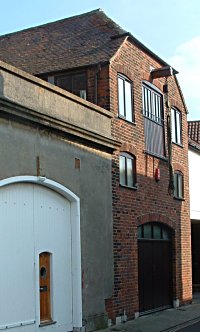
By the early years of the 17th century most of the earlier buildings had been replaced as the current road pattern became more established with buildings fronting the roadway. It was at this time that the surviving building known today as Popinjays is believed to have been constructed, though it was originally 2m longer. Close by, again facing Oyster Street, were two new houses built of red brick with semi-basements. Behind them were the remains of a forge, gulleys, drains, pits and wells, whereas on the land formerly occupied by the docks there is evidence of an attempt to reclaim part of the Camber using rectangular limestone revetments. Temporary buildings used these walls for foundations.
The modern road patterns became firmly established during the late 17th and 18th centuries with substantial buildings lining the streets. Some still survived from the previous era whilst newer houses filled in the gaps between them. Many homes had outhouses or extensions. On the west side of Oyster Street, at its junction with White Hart Lane domestic dwellings of red brick which had fireplaces, internal walls and stairs were constructed over redundant tobacco pipe kilns. One kiln was a single flue updraught type having an inner structure of red brick bonded with yellow clay; an outer structure consisted of large stones and pebbles. The stoke hole was square and built of red brick. It was two stepped and contained much black ash and many broken clay pipes, those from the last firing provided the dating for the kiln. Those bearing the letters I.M. and W.S. (John Moth and William Stretchley) are dated to c1690.
As with all previous phases of this site a number of wells were uncovered. One from the north-east section of the site had a 4m diameter construction shaft, an internal diameter of 1.75m and a depth of 6m. It was constructed of cobbles with a wooden plank liner secured by dowelled sectional wooden collars. Between the two was a red clay sealer, 25cm thick. In the top metre there was a stone lining which originally carried a timber framed winding gear, fragments of which were recovered from the infill.
From the late 18th century onwards, the entire site was occupied by purpose built brick buildings. Central to this was Anglesea Court, comprising five dwellings and a public house, the Anglesea Tavern (later the King and Queen and finally the Camber Cafe). John Pounds Ragged School occupied the north-west corner of the court and later became a warehouse.
In the 1970s the whole area was redeveloped with modern town houses occupying the site of the excavations. The only buildings to have survived being Popinjays and it's unnamed neighbour.